A major surface dressing programme has now begun across the county
The Lincolnshire-wide scheme, one of the biggest ever undertaken and costing £6 million, is running from now until around the middle of June and will see a staggering 271 sites treated to stop potholes forming.
That’s around 188 miles of road that will get the road equivalent of creosoting a fence to protect the surface from bad weather and give another decade of use.
Set out in a straight line, those 188 miles are roughly the distance between Lincoln and Cardiff. Completed in around 10 weeks.
It’s a huge job with around 26,500 tonnes of aggregate used, supported by specialist plant, traffic management and the crews needed to deliver work at this scale. It is a significant commitment of funding and resources aimed at protecting the road network in a proactive way.
Why surface dressing is used
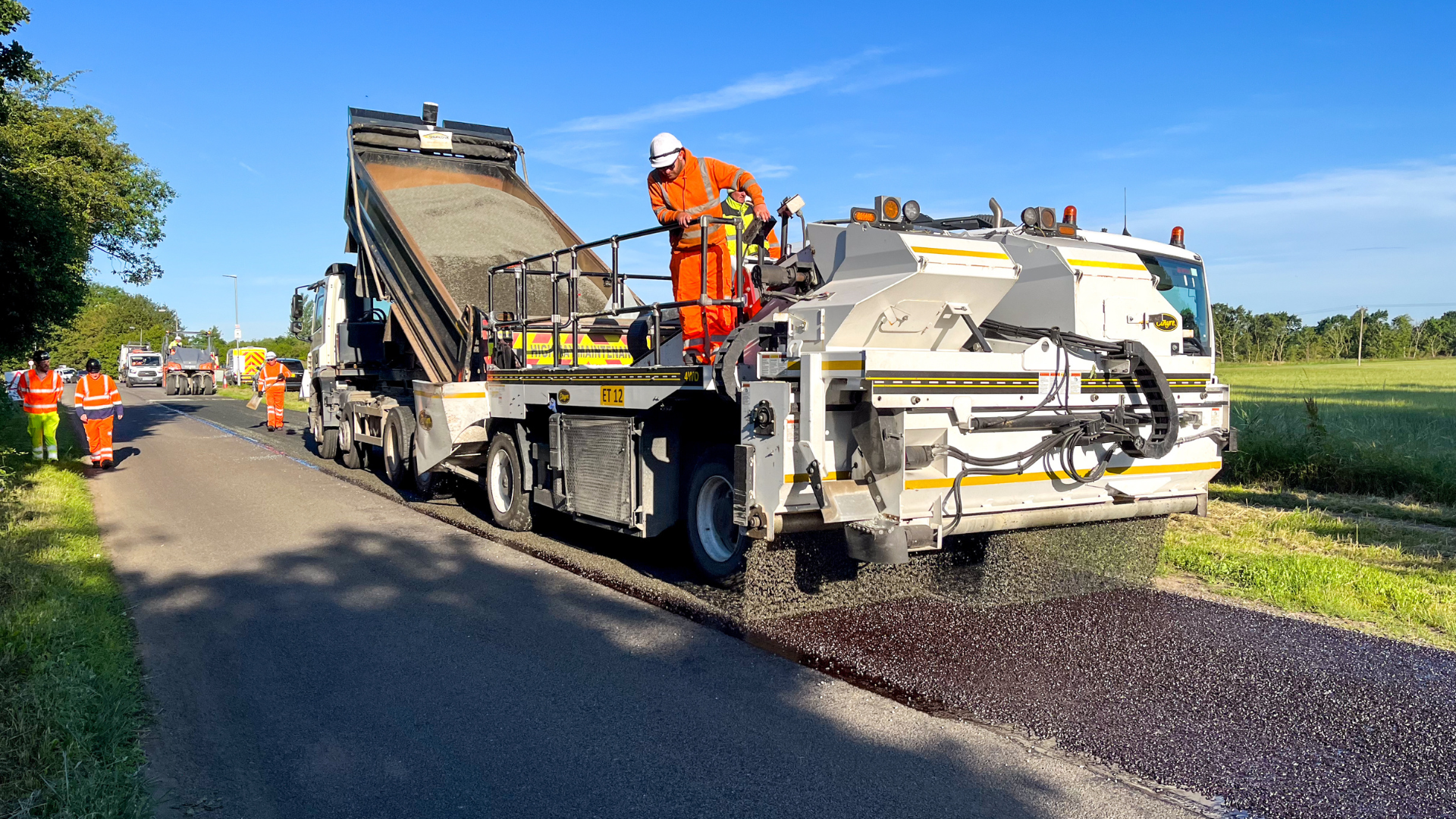
Surface dressing is a planned, preventative treatment applied to roads that remain structurally sound.
By sealing the surface and restoring texture, it slows down wear, prevents water reaching the underlying layers and reduces the likelihood of potholes forming.
The treatment also improves skid resistance, which is particularly important on rural routes where braking conditions can vary.
What happens before and during the works
Ahead of the programme starting, road studs will be removed or repositioned where required.
Ironwork such as gullies and manhole covers are masked to prevent the binder agent sticking to them.
The ‘dressing’ process involves applying a controlled spray of bitumen, followed by one or two layers of aggregate stone chips depending on the condition of the road.
The material is pressed down to ensure proper bonding which can meant that the surface might appear unfinished at first, but this is normal and it soon settles as traffic moves across it. A 20mph advisory speed limit will be in place at all sites to reduce the risk of loose chippings being displaced.
Sweeping and follow‑up treatments
Sweeping of the loose material that’s not been compacted will take place within 24 to 48 hours of the treatment, with a second sweep happening 7 to 10 days later. A further sweep will be carried out after around 13 weeks after the work, too.
Selected locations will also receive what’s called an ‘encapsulation treatment’ to help secure the chippings and provide additional protection to the new surface.
Road markings and studs will be reinstated within 28 days of completion.
Executive member for Highways at Lincolnshire County Council, cllr David East said: “The scale of this year’s programme is massive and reflects the council’s commitment to maintaining the road network in an effective and cost-efficient way.
“The benefit of surface dressing like this is that it allows large areas to be treated quickly and at a fraction of the cost of full resurfacing. By using this approach over the coming weeks I hope that people on the roads treated can appreciate what we’re doing, and they can understand that this treatment is a great way to extend the life of a road before potholes set-in.
“I know that the early loose‑chipping stage is not always popular, but ask that everyone sticks to the 20mph limit where it’s necessary and the end result will be worth it.”
Want to see the DAILY updates?
A live map showing daily work locations is available at www.lincolnshire.gov.uk/roadworks. Updates are made regularly, although timings may shift if weather conditions alter the schedule.
Here's a list of ALL the roads in this summer's scheme:
East
- Fleetway – North Coates
- B1225 Caistor High Street – Burgh on Bain
- B1196 Mawthorpe Road / Alford Road – Well
- Dogdyke Road – Coningsby
- A631 Main Road – South Elkington
- Stewton Lane – Louth
- B1195 Halton Road – Spilsby
- A1104 Miles Cross Hill – Alford
- Chapel Farm Drive (Estate) – Chapel St Leonards
- Church Farm Close – Chapel St Leonards
- Well Vale Drive – Chapel St Leonards
- North Road – Trusthorpe
- Southfield Lane – Fishtoft
- Bull Pasture – Frieston
- Ferry Road – Short Ferry
- Lusby Road – Hareby
- Winceby Road – Hammeringham
- Miningsby Road – East Kirkby
- Church Lane (Industrial Estate) – East Kirkby
- Manor Close – East Kirkby
- North End Road – Tetney
- Inghams Road – Tetney
- Waithe Lane – Waithe
- Oslears Lane – Maidenwell
- Farforth Lane – Farforth
- Horncastle Road – Goulceby
- Biscathorpe Road – Biscathorpe
- Bardney Road – Newball
- Trunch Lane – Chapel St Leonards
- Sea Road – Chapel St Leonards
- Pinfold Lane – Great Steeping
- Ingoldmells Road – Addlethorpe
- Walls Lane – Ingoldmells
- Torrington Lane – West Torrington
- Hainton Lane – Bleasby
- Bond Hayes Lane – Hagworthingham
- Church Lane – Hagworthingham
- Manor Road – Hagworthingham
- Road from Sausthorpe to Raithby Cross – Raithby
- Maddison Lane – Partney
- Greenfield Lane – South Thoresby
- Keal Hill – West Keal
- West Keal Road – Old Bolingbroke
- Hagnaby Lane – Keal Cotes
- Bar Green Lane – Stickney
- Ketsby Lane – Ketsby
- B1190 Bardney Road – Tupholme
- B1190 Horncastle Road – Bardney
- B1190 Main Street – Bucknall
- New End – Hemingby
- West Lane – Baumber
- Church Lane – Baumber
- Bassingham Lane – Scremby
- Cooks Lane – Scremby
- Greengate Road – Scremby
- Alford Road – Brinkhill
- Station Road – Burgh Le Marsh
- Wrights Lane – Friskney
- Common Road – Wrangle
- Church End – Wrangle
- Hampton Lane – Old Leake
- Willows Lane – Sibsey
- A52 Huttoft Road – Sutton on Sea
- A52 Croft Bank / Wainfleet Road – Croft
- Wedland Lane – Thorpe St Peter
- Cork Lane – Thorpe St Peter
- Wilshed Lane – Burgh Le Marsh
- Lane from Gravel Pits Lane – Bratoft
- Hunters Lane – Tattershall Thorpe
- Hundle House Lane – New York
- Firebeacon Lane / Bull Bank – Fulstow
- A16 Grimsby Road – Louth
- B1200 Kenwick Road / Legbourne Road – Louth
- B1203 Kirmond Road – Kirmond le Mire
- A158 Burgh Le Marsh Bypass – Burgh Le Marsh
- Gunby Road – Welton Le Marsh
- Unnamed road between Great Steeping Road and Monksthorpe Lane – Great Steeping
- Candlesby Road – Great Steeping
- Richmond Drive – Skegness
- Mill Lane – Wildmore
- Henry Lane – Tupholme
North
- Access road to Fir Tree Farm off Carr Lane – Blyton
- Front Street – Morton
- St Pauls Road – Morton
- The Belt Road B – Gainsborough
- Love Lane – Gainsborough
- Middlefield Lane – Gainsborough
- Park Springs Road – Gainsborough
- Copper Beech Close – Gainsborough
- Normanby Cliff Road – Normanby by Spittal
- Croft Lane – Cherry Willingham
- Midholm – Cherry Willingham
- Westholm – Cherry Willingham
- Oakwood Close – Cherry Willingham
- Lady Meers Road – Cherry Willingham
- Fiskerton Road East / Lincoln Road – Cherry Willingham
- Washingborough Road – Heighington
- Station Road – Heighington
- Branston Road / Station Road – Heighington
- Smithy Lane – Bigby
- Brigg Road – South Kelsey
- Forge Close (incl. Westerly Court junction) – South Kelsey
- Glebe Close – Ingham
- B1398 Middle Street / The Cliff / Cow Hill – Harpswell, Glentworth, Fillingham, Ingham
- Snelland Road – Snelland
- B1378 Skellingthorpe Road – Lincoln
- The Orchard – Washingborough
- B1190 Lincoln Road – Washingborough
- Low Wood Lane – Eagle
- Swinderby Road – Eagle
- A159 Blyton Road – Gainsborough
- Spital Hill / Corringham Road – Gainsborough
- Foxby Lane – Gainsborough
- Foxby Hill / Foxby Lane – Gainsborough
- A156 Lea Road – Gainsborough
- Caistor Lane – Tealby, Walesby
- Walesby Road / Rasen Road / Walesby Hill – Walesby
- Swallow Vale – Swallow
- Church Lane (incl. service road / layby) – Usselby
- B1205 Grayingham Road – Grayingham
- Station Road / The Fairways / Cowdale Lane – Torksey
- Ingham Road – Stow
- Fen Lane / Main Street – Burton
- B1398 Middle Street – Burton
- Station Road (Harby Lane) – Saxilby with Ingleby
- Roadwood Lane – Kettlethorpe
- Mill Lane – North Hykeham
- Eagle Road – North Scarle
- High Street – Upton
South
- Linden Way – Pinchbeck West
- Mayfield Close – Pinchbeck
- Pennyfield – Pinchbeck
- Blue Gowt Lane / Drove – Pinchbeck
- Van Gogh Drive – Spalding
- Rembrandt Way – Spalding
- Juniper Crescent – Spalding
- Hurldetree Bank – Whaplode St Catherine
- Stone Gate – Cowbit
- Curlew Drive – Cowbit
- The Pastures – Cowbit
- Meadow Walk – Cowbit
- Milfoil Lane – Cowbit
- Teal Grove – Cowbit
- The Tillney – Whaplode
- Franklin Walk – Whaplode
- Golden Harvest Way – Whaplode
- Chapel Gate – Gedney
- St Marys Meadows – Gedney
- Church Hill Court – Long Sutton
- Chestnut Road – Boston
- Middle Drove – Boston
- Sherwood Avenue – Boston
- Sheriff Way / Robin Hoods Walk – Boston
- Robin Hood’s Walk – Boston
- Fishtoft Road – Fishtoft
- Church Green Road – Fishtoft
- Kirton Drove – Amber Hill
- Baythorpe – Swineshead
- A6121 Stamford Road – Lound
- A6121 Main Road – Toft
- A52 Sleaford Road – Boston
- B1397 Boston Road / London Road – Kirton
- West Cob Gate – Moulton
- Park Road – Holbeach
- Battlefields Lane North – Holbeach
- Cackle Hill Lane – Holbeach
- Main Road – Wigtoft
- Hipper Lane – Wigtoft
- Wigtoft Bank – Wigtoft
- Hurn Bank – Holbeach Hurn
- Eastern Road / Barge Road – Holbeach St Marks
- St Marks Road – Holbeach St Marks
- Lincoln Lane – Holbeach St Marks
- Middle Marsh Road – Holbeach St Marks
- B1359 Wisbech Road – Long Sutton
- Hospital Road / Cocklehole Road – Sutton Bridge
- Haycroft Lane – Fleet
- Hazelwood Lane – Fleet
- Church End / Maisdyke Lane – Fleet Hargate
- Five Bells Lane – Holfleet Stow
- Fishmere End Road – Kirton
- Cranmore Drove – Deeping St James
- Gosberton Bank – Gosberton
- Church Lane – Algarkirk
West
- Folly Lane – Hough on the Hill
- Lower Road – Hough on the Hill
- Goodliff Road – Grantham
- Earlesfield Lane – Grantham
- Harrowby Lane – Grantham
- Lower Lodge Lane – Harlaxton
- The Drift – Harlaxton
- Burton Road – Little Hale
- Chapel Lane – Little Hale
- B1394 Main Road – Little Hale
- Carterplot Road – Heckington
- Whitecross Lane – Burton Gorse
- B1188 Sleaford Road – Nocton
- B1191 Timberland Road (part) – Scopwick (Kirkby Green)
- B1189 High Street – Billinghay
- First Hurn Drove – Billinghay
- Skinners Lane / Lawn Hill Farm – South Kyme
- Careby Road / Holywell Road – Hollywell to Careby
- Main Street – Careby
- Castle Bytham Road / Swayfield Road – Swayfield to Castle Bytham
- High Street – Swayfield
- Aunby Hamlet Road – Aunby
- A6121 Tinwell Road – Stamford
- A151 Village Street – Birkholme
- Hill Rise – Coleby
- Fox Hall Lane – Asgarby
- Boston Road – Sleaford
- Drove Lane / The Drove – Sleaford
- School Lane – Silk Willoughby
- Willoughby Road – Rauceby
- Fen Road – Dowsby
- B1177 Main Road – Dunsby
- High Street North / Fen Road – Ruskington
- Heath Lane / Barkston Heath Road – Belton
- Hopyard Lane / Marsh Lane – Brant Broughton
- South Heath Lane – Fulbeck
- A607 Main Road / Cliff Road – Leadenham
- Newark Road – Stapleford
- Thurlby Road – Bassingham
- Fosse Lane / Old Haddington Lane – Thorpe on the Hill / Aubourn with Haddington
- Mareham Lane – Threekingham
- Abbey Lane – Sempringham
- Scotland Lane – Ingoldsby
- Lower Bitchfield Road – Bitchfield
- B1176 Boothby Pagnell – Boothby Pagnall
- The Pastures – Old Somerby
- Doctors Lane – Dunsby to Rippingale
- Kirkby Underwood Road / Callans Lane / The Green / Rippingale Road – Kirkby Underwood
- Hawthorpe Road / Edenham Road / Bulby Road / Main Road / Elsthorpe Road – Bulby
- Corby Road – Swayfield
- Corby Road / Swayfield Road – Swayfield
- Hall Lane – Osgodby
- A15 Mareham Lane – Aslackby
- A607 Lincoln Road – Barkston
- West Street – Barkston
- Church Street / Honington Road – Barkston
- Minnets Hill – Barkston
- Access to Willoughby Heath Farm – Ancaster
- Haceby Road / Haceby North Road – Haceby
- Peck Hill / High Street – Ropsley
- Broadgate Road / Morkery Lane – South Witham to Castle Bytham
- A151 Flyover – Colsterworth
- Crabtree Road – Skillington
- Dallygate – Great Ponton
- Fen Lane – Long Bennington
- Folly Lane – Norton Disney